OS1/11/60/3


| List of names as written | Various modes of spelling | Authorities for spelling | Situation | Description remarks |
|---|---|---|---|---|
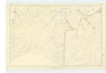
| LONG SHANK | Long Shank Long Shank Long Shank |
JS. Gilchrist William Penderleith Co. [County] Map Statistical Acct. [Account] of Scotland |
022 | A long ridge of an eminence at the East side of Jeffries Course. |
| JEFFRIES CORSE | Jewffries Course Jeffries Course Jeffries Corse |
JS, Gilchrist William Penderleith |
022 | A hill of considerable height forming part of the range called Moorfoot Hills, On it is a Trigl.[Trigonometrical] Station called by Trigl. [Trigonometrical] party " Jeffries Course".- |
| HAWKSTER GILL BURN | Hawkster Gill Burn Hawkster Gill Burn Hawkster Gill Burn Hawkster Gill Burn |
JS. Gilchrist Wm. William Penderleith Co. [County] Map Map of Roads |
022 | A small stream having its rise on Jeffries Course, and running Easterly to its junction with Gladhouse Burn. |
Continued entries/extra info
[page] 3 Parish of TemplePage 21 Long Shank
21 Jeffries Course - Corse - a Mile - Jamieson's Dictionary
21 Hawkster Gill Burn
Long Shank -- about 1 7/8 miles N.W. [North West] from [Trigangulation point] on Blackhope Scar.
[Additional Note] Long Shank Hill -- [arrow to County Map entry; reverse arrow from] Statistical Account of Scotland [to second] Long Shank Hill [entry].
Jeffries Corse -- about 2 miles W.N.W. [West North West] from [Trigonometrical point] on Blackhope Scar.
[Additional Note] Corse- -- a Mill. Jamiesons Dictionary
Hawkster Gill Burn -- Rises about 2 1/8 miles W by N. [West by North] from [Trigonometrical point] on Blackhope. Sar
[Number in margin for all 3 entries] 21
Transcribers who have contributed to this page.
Chr1smac -Moderator, ADobie
Location information for this page.