OS1/11/43/32


| List of names as written | Various modes of spelling | Authorities for spelling | Situation | Description remarks |
|---|---|---|---|---|
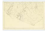
| COBINSHAW RESERVOIR | *Cobinshaw Reservoir ^Cobinshaw Reservoir +Union Canal Reservoir |
*County Map ^John Lind, S [South] Cobbinshaw *Andrew Gray, Todholes ^Map of Reservoir by James Hor [--] +Sketch of Roads by J. Flint |
016 | A very extensive Reservoir pertaining to the Union Canal it was formed A.D 1820 by the Union Canal Company This Reservoir was formed at comparatively little expence [expense], the natural conformation, and the quality of the ground being very favourable viz an Extensive and deep Morass or Bog There is an embankment across the Reservoir which divides it in two parts and Serves as a Road to South Cobinshaw The only artificial embankment necessary for the formation of the Reservoir is at the North end and only 12 Chains long. The company are bound by penalty not to allow the water to rise higher than a certain point; And they employ a Servant to attend to the repairs, to the height of the water, and to watch over their interest at the Loch. The Reservoir was imp [impounded ?] in the years 1830 and 1844 and now occupies an area of 400 acres The waters are principally derived from the adjacent moors but Some main Springs of excellent water run into it |
Continued entries/extra info
[Page] 32List of Names collected by 2nd Corpl [Corporal] W Rogers RS [Royal Sappers] & Miners
Plan 16.A Trace 2
[Object] A Reservoir
[Parish] W [West] Calder
Transcribers who have contributed to this page.
JCB
Location information for this page.
Linked mapsheets.