OS1/11/13/30


| List of names as written | Various modes of spelling | Authorities for spelling | Situation | Description remarks |
|---|---|---|---|---|
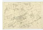
| CURRIE [village] | Mr. Robt. [Robert] Palmer Schoolmaster Currie Map of Edinburgh Shire Statistical accound of Scotland &c. &c. |
005 | Six miles distant from Edinburgh and on the road to Lanark stands the village of Currie, it consists of the Parish Church, and school, a manse, two large farm houses with offices and a thrashing machine attached to each, and about 50 Cottages occupied by farm labourers, and operatives who are employed in the paper mills in the vicinity. The "Water of Leith" runs through it; that part on the south is on the land of Malleny, that on the north is on the land of Riccarton. Currie is said to be very ancient, it is supposed to be the "Koria" of Ptolemy and Richard of Cirencester, but although this may be the case the name is still of Celtic derivation, being from the word "Cuere" or Corrie signifying a hollow place, the village lying in such a situation on the Water of Leith. |
Continued entries/extra info
collected by c.a. J McDiarmid 4th Feby 1852Plan 5.D
A Village
Parish of Currie
Transcribers who have contributed to this page.
Eebee
Location information for this page.
Linked mapsheets.