OS1/11/13/12


| List of names as written | Various modes of spelling | Authorities for spelling | Situation | Description remarks |
|---|---|---|---|---|
| CURRIE [village] | Currie Currie Currie Currie |
Mr. Robert Palmer Map of Edinburghshire Statistical account of Scotland Co. [County]Map. |
005 | A considerable village situated on the banks of the Water of Le[ith]. In it is the Parish Church and school the manse, two large fa[rm] houses, with offices including a thrashing machine attached to each, and about 50 cottages occupi[ed] by farm labourers, and other wo[rk] people who are employed in the paper Mills in the vicinity - That part on the south of the Water of Leith is on the land of Malleny that on the north is on land of Riccarton. |
| CURRIE STATION | Currie Station Currie Station |
Mr. I. Johnston William Dawson |
005 | A railway station on the Caledon [Caledonian] Railway 5 1/2 miles from Edinb [Edinburgh] |
Continued entries/extra info
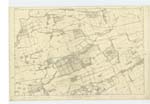
[page] 12 Parish of CurrieForm 136 Page
30 -- Currie -- N.[ North] Eastern part of the Parish of Currie
29 -- Currie Station -- About 1/2 Mile N.W. by N. [North West by North] of Currie.
Transcribers who have contributed to this page.
ADobie
Location information for this page.
Linked mapsheets.