OS1/21/17/27


| List of names as written | Various modes of spelling | Authorities for spelling | Situation | Description remarks |
|---|---|---|---|---|
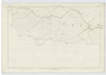
| SOUTH BOTTOM (In Ruins) | South Bottom | T.R. Scott Esq. Factor to the Earl of Home Reverend William Gouldie Minister Crawfordjohn Parish Mr Robert Robb: Schoolmaster Crawfordjohn Parish Mr James Watson Merchant Crawfordjohn Parish |
045 | The ruins of a cothouse - which is now used - with the enclosures about it. as sheep folds - it is the property of the Earl of Home |
| MID HILL | Mid Hill | T.R. Scott Esq. Factor to the Earl of Home Reverend William Gouldie Minister Crawfordjohn Parish Mr Robert Robb: Schoolmaster Crawfordjohn Parish Mr James Watson Merchant Crawfordjohn Parish | 045 | A small Heathy Pasture Hill the property of the Earl of Home |
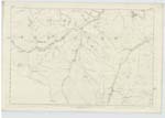
| DUNEATON WATER | Duneaton Water | T.R. Scott Esq. Factor to the Earl of Home Reverend William Gouldie Minister Crawfordjohn Parish Mr Robert Robb: Schoolmaster Crawfordjohn Parish Mr James Watson Merchant Crawfordjohn Parish Forrest's County Map dated 1816 Johnston's County Map |
045; 046 | A large stream which rises on the South side of Cairn Table. and for a considerable distance forms the Boundy. between the Phs of Douglas and Crawfordjohn it then enters the Parish of Crawfordjohn and flows close to the village of the same name. its average width is about 80 links. it then forms the Boundy between Crawfordjohn Parish and that of Wiston & Roberton. and after a course of about 18 miles it joins the Clyde about 2 miles North of the Village of Abington. |
| PANBRECK BURN | Panbreck Burn | T.R. Scott Esq. Factor to the Earl of Home Reverend William Gouldie Minister Crawfordjohn Parish Mr Robert Robb: Schoolmaster Crawfordjohn Parish Mr James Watson Merchant Crawfordjohn Parish | 045 | A small stream which rises on the East side of Panbreck Hill. and flows in a N.E. direction. it has a couse of about 1½ miles. and joins Duneaton Water at South Bottom |
| SCAR BURN | Scar Burn | T.R. Scott Esq. Factor to the Earl of Home Reverend William Gouldie Minister Crawfordjohn Parish Mr Robert Robb: Schoolmaster Crawfordjohn Parish Mr James Watson Merchant Crawfordjohn Parish | 045 | A small stream which collects from surface water and after a course of about 60 chains in a N.E. direction it joins Duneaton Water 35 chains South East of South Bottoms. |
Continued entries/extra info
[Situation of South Bottom] N.Side of Panbreck Burn and near its junction with Duneaton Water. on Sheet 45[Situation of Mid Hill] Between Scar Burn and Lairds Burn - on Sheet 45
[Situation of Duneaton Water] Extends along the N Boundary of Crawfordjohn Parish for the most of its course. Sheets 45 & 46
[Situation of Panbreck Burn] Between Fingland Hill and Scar Hill on Sheet 45
[Situation of Scar Burn] Between Scar Hill and Mid Hill. on Sheet 45
Transcribers who have contributed to this page.
douglas
Location information for this page.