OS1/21/9/1


| List of names as written | Various modes of spelling | Authorities for spelling | Situation | Description remarks |
|---|---|---|---|---|
| CARMICHAEL | Carmichael Carmichael Carmichael |
Statistical Account Johnston's County Map Forrest's Map of Lanarkshire |
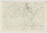
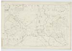
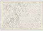
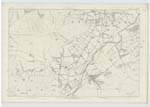
032; 033; 038; 039 | This parish has retained the same name from time immemorial. It was probably placed under the tutelage of St. Michael when it was only of a very limited extent, perhaps a Chapelery founded by some ancestor of the family of Carmichael and it afterwards retained the same name and claimed patronage of the same Saint when its dimensions were enlarged by the annexation of a part of the contiguous parish of Douglas. ** There are several places in the parish which still retain the names of saints in the Romish calander, such as St Michael's Well and Bog, now happily drained and very productive and Bride's Close - evidently consecrated to St Bride or Bridget. Stat Acct P517. This Parish is bounded on the north by the parishes of Lanark and Pettinain; on the east by Covington; on the South by Wiston and on the west by Lesmahagow and Douglas. The surface of the parish presents a very unequal and diversified aspect, the mountain range of Tinto looking down from a commanding elevation upon the several hills and valleys which lie at its base and sending from its rocky caverns many tributary streams to the Clyde and Douglas Water ** |
Continued entries/extra info
Parish of Carmichael [in header]Lanarkshire [across several columns]
Transcribers who have contributed to this page.
JCB
Location information for this page.