OS1/20/33/27


| List of names as written | Various modes of spelling | Authorities for spelling | Situation | Description remarks |
|---|---|---|---|---|
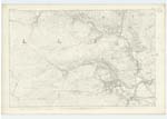
| STRANFASKET HILL | Stranfasket Hill Stranfasket Hill Stranfasket Hill Stranfasket Stronfascat Stranfasket |
Henry Johnstone N.S. James McCartney N.S. James Bryden n.s. Val. [Valuation] Roll 1819 Val. [Valuation] Roll Anct. [Ancient] Ainslies Map 1820 |
015 | [Situation] About ½ mile West by North of Stranfasket. A large portion of a range of hills on the farm of Stranfasket (hence the name) It runs in a North West direction for about 1½ miles from Crummy Burn. Its Surface consists chiefly of rocky heathy pasture also potions of it have seperate & independent names Such as Larvey Hill. Broadpark &c.On the part Called Broadpark is a Trigl. [Trigonometrical] Station Called by Trigl. [Trigonometrical] Party 'Strangassan' |
| ROUGH STRAND | Rough Strand Rough Strand |
Henry Johnstone n.s. James McCartney |
015 | [Situation] Running in a S.E [South East] direction between Broadpark Knowe and Stranfasket Hill for a distance of 5/8 mile to its junction with Crummy Burn A Small Stream or burn taking its rise near the base of Stranfasket Hill an running in a South Easterly direction to its influx with Crummy Burn. |
Continued entries/extra info
[Page] 27Parish of Kells
Form 136 Page
60 Stranfasket Hill
59 Rough Strand
Transcribers who have contributed to this page.
DANIALSAN
Location information for this page.
Linked mapsheets.