OS1/20/158/7


| List of names as written | Various modes of spelling | Authorities for spelling | Situation | Description remarks |
|---|---|---|---|---|
| SHAW HOLE | Shawhole Shawhole Shaw Hole Shaw Hole Shaw Hole |
Thomas Ritson John Williamson Alexander Rain Alexander McMein See page 102 Ainslies Map 1820 |
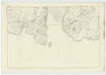
054 | [Situation] About 1 3/4 Miles W. by N. [West by North] of Balmae A small creek or inlet on the sea shore of the farm of Balmangan Its coast consists of rugged rocks and boulders. possible it has derived its name from the wood on its west side, as Shaw signifies a Wood or thicket. - |
| KIRKCUDBRIGHT BAY | Kirkcudbright Bay Kirkcudbright Bay Kirkcudbright Bay |
Statistical Gazetteer of Scotland Ainslies Map Map of Co. [County] 1820 |
054 | [Situation] Running inland fr. [from] Little Ross (on the S. [South]) to St. Mary's Isle on the North. A considerable Bay in the most Southerly point of Kirkcudbrightshire It extends from Little Ross on the South to St. Mary's Isle on the North, and is bounded on the West by Borgue on the North by Twynholm and on the East & North East by Kirkcudbright parish. It affords one of the best Anchorage on the South Coast of Scotland, and is naturally safe and Sheltered from all winds by Little Ross lying across its entrance, allowing a channel of 1 1/2 Miles, safe and bold on both sides & having behind the a roadstead with 16 ft. at Low Water & 40 at high, where vessels may ride with safety in gales from any point. From a small creek called Balmangan Bay, to Torrs Point on the opposite side, A considerable bar of sand extends across the Bay, which causes vessels of large burden to ly out at Low Neap tides, or other wise by sailing up the channel of the Dee on the East Coast.-- |
Continued entries/extra info
[Page] 7Parish of Borgue
Form 136 Page
71 Shaw Hole
73 Kirkcudbright Bay
Transcribers who have contributed to this page.
Nellie- Moderator
Location information for this page.
Linked mapsheets.