OS1/20/103/7


| List of names as written | Various modes of spelling | Authorities for spelling | Situation | Description remarks |
|---|---|---|---|---|
| LAUGHENGHIE HILL | Laughenghie Hill Laughenghie Hill Laughenghie Hill Laughengee Laughenghie Laughenghie |
Samuel McLelland John Ferguson John Denniston Gatehouse Ainsly's Map revised 1819 valuation roll 1819 valuation roll ancient |
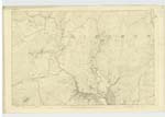
037 | [Situation] About 1 3/4 miles N [North] E [East] by E [East] of Burnfoot (in ruins). A considerable hill on the farm, formerly called Laughenghie (hence its name) but now in the farm of [Grobdale] of Girthon. On its summit is a Trigl [Trigonometrical] Station called by Trigl [Trigonometrical] Party ["Loughengee"] |
| BROCK KNOWES | Brock Knowes Brock Knowes |
John Ferguson John Denniston Gatehouse |
037 | [Situation] 2 3/8 miles N. [North] E. [East] of Burnfoot (in ruins). A few hillocks on the western side of Grobdale Lane, and on the farm of Girthon, Grobdale. It had been resorted by Badgers hence the name Brock the scotch name for Badger. |
Continued entries/extra info
Parish of Girthon -- [page] 7Page [...]5 Laughenghie Hill
Page [...]5 Brock Knowes
[Note] "Broc" - a badger Gaelic Dictionary
"Knowes" plural of "Knowe" - a little hill Scottish Dictionary
Transcriber's notes
Words are missing in fold on left hand side.Transcribers who have contributed to this page.
raschdorff
Location information for this page.
Linked mapsheets.