OS1/20/101/5


| List of names as written | Various modes of spelling | Authorities for spelling | Situation | Description remarks |
|---|---|---|---|---|
| CAIRNSMORE OF FLEET | Cairns-more Cairns-more Cairnsmore Cairnsmuir Cairns Muir Cairnsmore of Fleet |
John Burnie Captn [Captain] Dinneston Statistical Account page 315 - - Ainslies Map 1820 Map of County In Name ListS Plan. 29.D &. 36.B. |
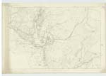
036 | [Situation] About 2 mileS N. [North] by W. [West] of Craig (houSe) The largest and highest Mountain or. range in the locality, Situated in the parishes of Minnigaff &. KirKmabreck, And Was found (Many years ago, to be 2222 feet above the level of the Sea,) by the Civil engineers employed by Government. Its Surface is wholly Granite, and partially Covered with heath, on its Summit there is a plain of conSiderable extent with less heath And More Soil &. herbage than upon its Sides. Also on its Summit is an ancient Cairn &. on which stands a Trigl. [Trigonometrical] Station Called by Trigl. [Trigonometrical] Party "CairnsmuirS. [South] [? ]". The top of Cairnsmore Commands an extensive View of Many Counties in Scotland. The isle of Man, Ailsa Craig, the Mountains of Morne in Ireland, the Mountain Ranges of Cumberland &. wide expanse of the Irish Sea. - |
Continued entries/extra info
Parish of KirKmabrecK -- [Page] 5Form 136 Page
23 Cairns-more
Transcribers who have contributed to this page.
Molly Miller
Location information for this page.
Linked mapsheets.