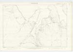
OS1/18/5/4


| List of names as written | Various modes of spelling | Authorities for spelling | Situation | Description remarks |
|---|---|---|---|---|
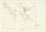
| COPPAY | Coppay Coppay Coppay Coppay |
Angus Morrison Admiralty Chart Black's Map Ainslies Map 1789 |
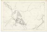
016 | This name is applied to a [small] island situate about 1 1/2 miles to [the] south west of Toe Head. It is covered with good rough [pasture] and is the property of the Earl of [Dunmore] & belongs to the parish of Harris. |
| ARD AN LAOIGH | Ard an Laoigh | Angus Morrison | 021 | Is applied to the most southern [point] of the island of Shillay which is very [-] seperated from the island at high [water] by a narrow precipitous rocKy [channel] The name signifies "Point of the [Calf] |
Continued entries/extra info
[page] 4Transcriber's notes
Words lost in fold of page.Transcribers who have contributed to this page.
Moira L- Moderator
Location information for this page.
Linked mapsheets.