OS1/18/1/1


| List of names as written | Various modes of spelling | Authorities for spelling | Situation | Description remarks |
|---|---|---|---|---|
| BARRA | Barra Barray |
Val [Valuation] Roll 1868.9 Johnston's Map Black's Map Fullertons Parliamentary Gazetteer Vol. [Volume] 7 p. [page] 113 Oliver & Boyd's Almanack 1869 p. [page] 142 Admiralty Chart Islets of Britaine by Walter Cooper Dendy p. [page] 91 New Statistical Account. p. [page] 198 |
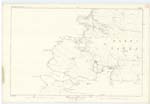
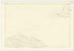
064 | The Parish of Barra is formed of that cluster of islands at the South West end of the Hebrides. It is bounded the North by a channel of 6 miles separating it from South Uist Parish. The islands of Rum and Canna are the nearest land to it on the East, distant about 26 miles. The islands of Coll and Tyree, are the nearest land to it on the South, distant about 30 miles and on the West it is bounded by the Atlantic Ocean. The parish Consists of the mainland of Barra, properly so Called. The main island is 8 miles in length and from 2 to 4 in breadth. The other islands in connection with this parish are Berneray, Mingulay, Pabbay, Lingay, Sandray, Vatersay, Muldoanich, Flodday, Hellisay, Funday, Fiary and several other small islands and islets which will be duly seen on reference to the several plans. The Ph. Parish of Barra is in the Presbytery of Uist, Synod of Glenelg and is the property of John Gordon Esq. Cluny Castle Aberdeenshire OVER |
Continued entries/extra info
[Page] 1Barra -- Inverness-shire
Transcribers who have contributed to this page.
Nora Edwards, Bizzy- Moderator, Rose Anne McGown
Location information for this page.