OS1/14/76/3


| List of names as written | Various modes of spelling | Authorities for spelling | Situation | Description remarks |
|---|---|---|---|---|
| PANBRIDE | Panbride Panbride Panbride Panbride Panbride Panbride |
Sherriff's List of meresmen New Stat. Acct. [Statistical Account] Johnston's Co. [County] map Old Stat. Acct. [Statistical Account] Fullarton's Gazetteer. Oliver & Boyd's Almanack |
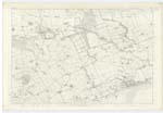
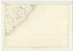
051; 052 | [Situation]In the S. [South] Eastern portion of Forfarshire adjoining the German ocean. A parish on the south-east verge of Forfarshire. bounded on the north by Carmyllie, on the north-east and east by Arbirlot and a detached portion of St Vigeans on the south east by the German ocean on the south-west by Barry and on the west by Monikie. Its figure nearly resembles the small segment of a flat ring the convex side turned to the south west and it measures nearly 5 miles in length from north to south east about two miles in mean breadth and is supposed to be about 5,400 acres in area. The Coast 2¼ miles in extent is flat and very rocky with a pebbly beach which occasionally affords some gems. The interior is in general flat but rises towards the north. The soil toward the Coast is sandy, in the central district it is clay on loam and toward the north is moorish. Limestone but of an inferior quality and not in plenty exists and sandstone both of an excellent sort for building and of the slaty kind which yields the Arbroath paving stone abounds and is worked. This parish is in the presbytery of Arbroath and Synod of Angus & Mearns |
Continued entries/extra info
[Page] 3Parish of Panbride
Transcribers who have contributed to this page.
Alison James- Moderator, noho
Location information for this page.