OS1/14/73/3


| List of names as written | Various modes of spelling | Authorities for spelling | Situation | Description remarks |
|---|---|---|---|---|
| MURROES [parish] | Murroes Murroes Murroes Muirhouse Muirhouse or Murroes Murroes (obsoletely Muirhouse) Murroes Murroes |
Sheriff's List of meresmen New Stat. Acct. [Statistical Account] Johnston's Co. [County] map Map of Co. [County] in New Stat. Acct. [Statistical Account] Old Stat. Acct. [Statistical Account] Fullarton's Gazetteer Oliver & Boyd's Almanack Anonymous Acct. [Account] Forfarshire 1682 Printed in Spottiswood miscellany |
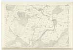
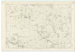
044; 050 | [Situation] In the south end of the Co. [County] of Forfar. A parish near the southern extremity of Forfarshire bounded on the north by Inverarity on the east by Monikie and Monifieth; On the south by Monifieth by the main body of Dundee and by Mains and on the west by Mains by the detached parts of Dundee and by Tealing. Its form is exceedingly irregular a projection going off westward from its south end and all the detached part of Dundee being an indentation on its west side. Its greatest length from north to south measured over the middle of the Dundee indentation is about 4½ miles. its greatest breadth from east to west in a line over the parish church and falling upon the southern part of the indentation is about 3½ miles, its mean breadth measured at intervals on the sort of segment which it forms round the indentation is about 1¼ mile and its area is about 7 square miles. Fithie Water pursuing a south-easterly direction runs two miles between it on the right bank and Tealing and the detached part of Dundee on the left and afterwards flows ¾ of a mile through the interior leaving the parish just after having split its water to form an islet, Murroes Burn coming in near the north-west [continued on page 4] |
Continued entries/extra info
[Page] 3Parish of Murroes
Transcribers who have contributed to this page.
Alison James- Moderator, Iain496
Location information for this page.