OS1/14/71/3


| List of names as written | Various modes of spelling | Authorities for spelling | Situation | Description remarks |
|---|---|---|---|---|
| MONIKIE | Monikie Monikie Moneekie Monikie Monikie Monikie |
Sheriff's List of Meresmen New Stat. Acct. [Statistical Account] Johnston's Co. [County] map Old Stat. Acct. [Statistical Account] Fullarton's Gazetteer Oliver & Boyd's Almanack |
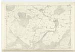
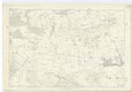
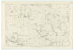
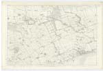
044; 045; 050; 051; 055 | [Situation] In the S.E. [South East] side of Forfarshire A parish in the south end of Forfarshire, bounded on the NW. [North West] by Inverarity on the NE. [North East] by the southern section of Guthrie and by Carmyllie on the east and south-east by Panbride and Barrie and on the west and south-west by Murroes and Monifieth. Its greatest length in a straight line between two angles which terminate it on the north and south is about 7 miles, its greatest breadth in a line due east and west over the parish church is 5 miles. A small tract in the extreme south corner consists of sandy downs. The land for 2¾ miles thence northward is distinguished for fertility, has a southern exposure and presents a warm and wealthy appearance. A large elongated hill or hilly ridge called Dunie or Camustown now interposes from east to west and sections off a colder climate and an inferior soil lying to the north. This parish is in the presbytery of Dundee Synod of Angus and Mearns. There are no detached portions of Monikie Ph. [Parish] nor are there any detached portions of other parishes within that of Monikie |
Continued entries/extra info
[Page] 3Parish of Monikie
Transcribers who have contributed to this page.
Alison James- Moderator, NoraE- Moderator, Iain496
Location information for this page.
Linked mapsheets.