OS1/13/85/17


| List of names as written | Various modes of spelling | Authorities for spelling | Situation | Description remarks |
|---|---|---|---|---|
| SKEITH STONE | Skeith Stone Skeith Stone Skeith Stone |
Mr. James Nichol, Land Surveyor Cellardyke Mr. Gray Farmer Rennyhill Burgh Boundary Document |
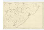
020 | [situation] About 20 Chains W.S.W. [West South West] from Kilrenny. This stone stands on a slightly rising part of Renny hill farm Its height above the ground is nearly 4 feet. It is about 3 feet broad, and 1 foot thick. On the side to the East is rudely cut the Mariners Compass, with 8 points. No date is discernible on it and there is no very satisfactory tradition regarding it. It is now one of the marks for defining the Parliamentary boundary. |
Continued entries/extra info
17 Parish of Kilrenny Plan 20C Trace 3.[Quotation]
"On a slightly elevated portion of ground to the west of the village of Kilrenny there is an upright Stone with some rude engraving somewhat resembling the mariners compass called Skeith or Skeigh or Scathe Stone but there is no satisfactory tradition concerning. It may possibly have been erected to commemorate some conflict which took place during the invasion of the East Neuk by the Danes." New Stat. Acct. [Statistical Account] of Fifeshire.
[signed] James Ireland c/a [Civilian Assistant] June 23rd 1853
Transcribers who have contributed to this page.
MaxInSpain
Location information for this page.
Linked mapsheets.