OS1/13/64/56


| List of names as written | Various modes of spelling | Authorities for spelling | Situation | Description remarks |
|---|---|---|---|---|
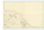
| KILDUNCAN WOOD | Kilduncan Wood Kilduncan Wood Kilduncan Wood |
Mr Lawrence Scott Joiner Little Kilduncan Mr David Duncan Farmer Kilduncan Plan of the Farm |
013 | [situation] S.W. [South West] of Little Kilduncan. A Considerable Strip of Wood, mostly full grown Fir, on the Farm of Kilduncan. The property of John Beatson Bell Esq. Glenfarg. |
| KILDUNCAN BURN | Kilduncan Burn Kilduncan Burn |
Mr David Duncan Farmer Kilduncan Mr Lawrence Scott Joiner Little Kilduncan Mrs Allan. Upper Kenly |
013 | [situation] Rises E. [East] of Little Kilduncan. This Small stream rises in the Kings Muir, Separates the Estate of Kippo on the one side, from those of Kenly and Kilduncan on the other. Flowing eastward on entering the Pitmilly estate it assumes the name of the Pitmilly Burn, passing through this estate it falls into the Sea. [Note] See note page 52 |
Continued entries/extra info
[Page] 56 -- Parish of Kingsbarns -- Plan 13C. -- Trace 6[Note - Pencil. Kilduncan Burn] Give a distance to fix the point where the name changes. omo [Ordnance Map Office]
[signed] James Ireland c/a [Civilian Assistant] 17th June 1853
Transcribers who have contributed to this page.
Chr1smac -Moderator, MaxInSpain
Location information for this page.
Linked mapsheets.