OS1/13/61/19


| List of names as written | Various modes of spelling | Authorities for spelling | Situation | Description remarks |
|---|---|---|---|---|
| ST ANDREWS [parish] | St. Andrews St. Andrews St. Andrews St. Andrews St. Andrews St. Andrews |
Full. [Fullarton's] Gazetteer Stat. Acct. of Co. [Statistical Account of County] Old Stat [Statistical] Account Co. [County] Map Oliver & Boyd's Almanac Sibbald's Hist. [History] of Fife |
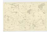
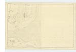
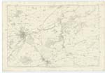
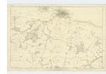
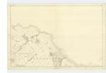
006; 007; 011; 012; 013 | [situation] In the Eastern Portion of the County of Fife. A parish on the eastern coast of Fifeshire, bounded on the North by the Eden River, and its estuary which separates it from the parish of Leuchars, on the northeast by the German Ocean, on the east by the Parishes of Kingsbarns and St. Leonards, and on the south & west by the parishes of Denino, Cameron, Ceres and Kemback. Its greatest length is about 10½ miles from Northwest to southeast, And its average breadth does not exceed 1¾ miles. No part of the parish rises to a great height the highest elevation is about 550 feet above sea level. The City of St. Andrews is in this parish, and is situated upon a rocky ridge, projecting into the Sea, at the bottom of the bay to which it gives its name, of which see descriptive remarks an an adjoining name List. There are two detached portions of St Leonards Ph. [Parish] within St. Andrews. - |
Continued entries/extra info
[Page] 19 -- Parish of St. Andrews.Transcribers who have contributed to this page.
Chr1smac -Moderator, MaxInSpain
Location information for this page.