OS1/13/59/53


| List of names as written | Various modes of spelling | Authorities for spelling | Situation | Description remarks |
|---|---|---|---|---|
| DENORK | Denork Denork Denork Denork |
Thomas R. McRitchie Proprietor Robert Hean Claremont George Wallace Upper Magask Stat. Acct. [Statistical Account] 1845 |
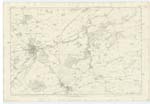
011 | [situation] About 2 1/4 Miles E. by N. [East by North] from Pitscottie. This is a lately erected dwelling house, beautifully situated on the north side of the Drumcarro Craig. Belonging to the house are stables and garden. The lands of Denork and Chieffy let for pasture. The house is occupied by the proprietor Thomas Elder McRitchie Esq. |
| DRUMCARROW CRAIG | Drumcarrow Craig Drumcarrow Craig Drumcarrow Craig Drumcarrow Craig |
John Forrester Drumcarro Coalpit Robert Hean Claremont George Wallace Upper Magask Stat. Acct. [Statistical Account] 1845 |
011 | [situation] About 2 1/4 Miles E [East] from Pitscottie. This is a short range of hills, covered with rocky and rough pasture. The highest and most easterly is generally known by the name of The Craig. Upon this summit is a 12 in. Trig. [12 inch, Trigonometrical] Station. The range is the property of James Holme Rigg Esq. |
Continued entries/extra info
53 Parish of Ceres Plan 11D Trace 4[signed] James Ireland cla [Civilian Assistant] 17th Sept. 1853
Transcriber's notes
"12 inch Trig." The Ordnance Survey carried out surveys at various scales. The "12 inches to the mile" is referred to here.Transcribers who have contributed to this page.
MaxInSpain
Location information for this page.
Linked mapsheets.