OS1/13/29/10


| List of names as written | Various modes of spelling | Authorities for spelling | Situation | Description remarks |
|---|---|---|---|---|
| BRACKS PLANTATION | Bracks Plantation Bracks Plantation Bracks Plantation |
Estate Map O T Bruce Esqr Mr F Howden Factor |
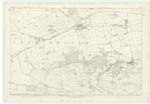
016 | A considerable sized inclosure planted with Fir on the South Side of Green Hill the property of O T Bruce Esqr. |
| BRACKS | Bracks Bracks Bracks |
Estate Map O T Bruce Esqr Mr F Howden Factor |
016 | A district or locality extending from the planted ground on the West side of Coal Pit Burn in a westerly direction to Balharvie Moss or more properly speaking to the west end of the Bracks Plantation, it is bounded on the North by Green Hill and on the South by Falkland Moss and road leading from Coal pit burn to Balharvie Moss. |
| LAIRD'S FAULDS | Laird's Faulds Laird's Faulds Laird's Faulds |
Estate Map O T Bruce Esqr Mr F Howden Factor |
016 | A portion of rough pasture adjoining the West side of Green Hill and nearly inclosed by an old fence on the West side and the Arraty Burn on the NW [North West] it was originally used as a place of Shelter for sheep from its low situation. |
Continued entries/extra info
[page] 10Plan 16D Trace 2 Parish of Falkland
Bracks Plantation situation -- 1 1/4 Miles N.W. [North West] of Easter Glasslie.
Bracks situation -- 1 1/4 Miles N.W. [North West] of Easter Glasslie.
Laird's Faulds sitaution -- 1 1/2 Miles N.W. [North West] of Easter Glasslie.
[Note] Fauld. Fold. Burn's Glossary.
Fauld. Fold. Jameson
Transcribers who have contributed to this page.
MaxInSpain , Jill S
Location information for this page.
Linked mapsheets.