OS1/13/134/3


| List of names as written | Various modes of spelling | Authorities for spelling | Situation | Description remarks |
|---|---|---|---|---|
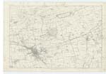
| ABERDOUR [parish] | Ph [Parish] of Aberdour Ph [Parish] of Aberdour Ph [Parish] of Aberdour Ph [Parish] of Aberdour Ph [Parish] of Aberdour |
Full. [Fullerton's] Gazetteer New Stat. [Statistical] Acct. [Account] Johnston's Co. [County] Map Sheriff's Co. [County] List of Parishes Old Stat. Acct. [Statistical Account] |
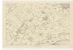
035; 036; 040 | [Situation] On the Southern Margin of the Co. [County] of Fife "A parish in the County of Fife, bounded by the parish Dalgety on the west, by Auchtertool on the north, by Kinghorn and Burntisland on the East, and by the Firth of Forth on the South. It is about 3 miles in length from east to West, and about as much from North to South. " A small part of the parish is detached from the rest, by the intervening parish of Burntisland". Full. [Fullerton's] Gazetteer. The greater part of the parish is tolerably well cultivated and enclosed. It abounds with Coal, lime and freestone. Near the coast on the South Side of the parish stands the town of Aberdour and on a flat on the top of a hill not far from the town there is one of those Cairns or tumuli so frequently met with in Scotland. A Coffin and several earthen vessels containing human bones were found in it. A small part of the parish is detached in the west by the intervening parish of Burntisland and Kinghorn and [.....] New Stat Acct [Statistical Account] |
Continued entries/extra info
[Page] 3Note: (Cairns) Situation of this Cairn cannot be pointed out, and therefore not on the plan - see reply to remark No. 109th on the plan.
OMO [Ordnance mapping office]
Note: Aberdour, Signifying the mouth of a Water
Note: No portion of any other parish is situated within Aberdour
Transcribers who have contributed to this page.
GreenflyNZ, JCB
Location information for this page.