OS1/13/7/33


| List of names as written | Various modes of spelling | Authorities for spelling | Situation | Description remarks |
|---|---|---|---|---|
| KELTYHILL WOOD | Keltyhill Wood Keltyhill Wood Keltyhill Wood |
Andrew Douie Esqr Robert Wishart Map of Minerals |
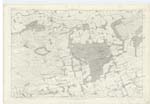
030 | [situation] About ⅝ Mile W. by S. [West by South] of Kelty. A tolerably large wood on the East side of Blairadam Park and situated between Drumnagoil Burn and Whitehouse Wood. It Consists of Ash Oak and Fir. |
| WHITEHOUSE WOOD | Whitehouse Wood Whitehouse Wood Whitehouse Wood |
Andrew Douie Esqr. Robert Wishart Map of Estate 1824 |
030 | [situation] About 1 Mile S.W. [South West] of Kelty. A large Wood lying on the South East Corner of Blairadam Park. It consists of Ash Oak Elm and Fir. |
| THORNTON WOOD | Thornton Wood Thornton Wood Thornton Wood |
Andrew Douie Esqr Robert Wishart Map of Estate 1824 |
030 | [situation] 1⅛ Miles S.W. [South West] of Kelty. A portion of Blairadam Woods adjacent to the farm of Thornton and situated on the South West Corner of Blairadam Park. |
Continued entries/extra info
[page] 33 Parish of Beath Trace 9Transcriber's notes
WOODEND WOOD was prepopulated on this page whilst THORNTON WOOD was on the previous page. This has been corrected [Moderator]Transcribers who have contributed to this page.
GreenflyNZ, MaxInSpain , Jill S
Location information for this page.
Linked mapsheets.