OS1/15/50/3


| List of names as written | Various modes of spelling | Authorities for spelling | Situation | Description remarks |
|---|---|---|---|---|
| DRY BURN | Dry Burn Dry Burn Dry Burn |
Robert Huntly David Broadwood Co. [County] Map (1799) |
012 | [Situation] About 1 1/8 Mile N. [North] from Innerwick Castle A Small stream or burn having its rise near the Summit of Watch Law and running in N. [North] Easterly direction to its influx with the Sea at SKateraw, (It is the Continuation of Woodhall Burn) |
| DRYBURN BRIDGE | Dryburn Bridge Dryburn Bridge |
David Broadwood Robert Huntly |
012 | [Situation] About 1 1/4 Miles N.N. [North North] West from InnerwicK Castle A county built bridge of one arch over Dry Burn on the turnpiKe Road from Edinburgh to Berwick, |
| SKATERAW | Skateraw Skateraw Skateraw Skateraw Skateraw |
D. Broadwood Mr Darling Co. [County] Map, (1799) Stat. Acct. [Statistical Account] 1845 List of Farms Co [County] Haddington |
012 | [Situation] Nearly 1 Mile N. [North] from InnerwicK Castle A farm house with out houses (including a thrashing machine) in good repair, having a large farm attached. The property of Mrs. Ferguson of Beil. |
Continued entries/extra info
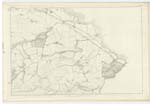
[Page] 312 B -- Parish of InnerwicK
33 - Dry Burn
35 - Dryburn Bridge
34 - Skateraw
Transcribers who have contributed to this page.
Bizzy- Moderator, Molly Miller
Location information for this page.
Linked mapsheets.