OS1/15/48/24


| List of names as written | Various modes of spelling | Authorities for spelling | Situation | Description remarks |
|---|---|---|---|---|
| OX CLEUGH | Ox Cleugh Ox Cleugh Ox Cleugh |
John Dods W. Brown Map of property |
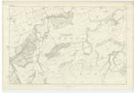
011 | [Situation] About 3/4 of a Mile S by E [South by East] from Halls. A narrow deep ravine through which a Small Stream having its rise on Halls Edge, and running northerly to its junction with Redscar Burn. |
| HERRING ROAD | Herring Road Herring Road Herring Road |
William Brown John Wood John Jaffray |
011 | [Situation] Passes East of Wester Hartside Edge about 7/8 of a mile SSE [South South East] from Halls. This name now applies to that part of the old Road from Dunbar to Lauder which crosses the unenclosed lands. It was formerly used for the conveyance of Herrings etc from Dunbar packhorse fashion, hence the name. |
Continued entries/extra info
[Page] 24Parish of Spott
Form 136 Page
58 Ox Cleugh
.. Herring Road
Transcriber's notes
An entry on this page for "Halls Edge" has ben scored out and is not transcribed.Transcribers who have contributed to this page.
DANIALSAN, JCB
Location information for this page.
Linked mapsheets.