OS1/15/48/19


| List of names as written | Various modes of spelling | Authorities for spelling | Situation | Description remarks |
|---|---|---|---|---|
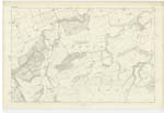
| HIGHSIDE HILL | Highside Highside High Side Highside Hill Highside Hill |
Mr Dods Map of Farm Forrests' Co. [County] Map William Brown John Wood |
011 | [Situation] About 3/4 of a mile N.E. [North East] from Halls. A small hill partly covered with furze. It is on the farm of Halls, and near to Black Loch |
| ICE CLEUGH | Ice Cleugh Ice Cleugh Ice Cleugh |
William Brown Mr Dods Map of Farm |
011 | [Situation] About 3/8 of a mile NNW [North North West] from Halls. A narrow Steep ravine through which a small stream runs having its rise near Pathhead farm house, and running [North] easterly to its junction with Bennet's Burn |
| LOTHIAN EDGE | Lothian Edge Lothian Edge Lothian Edge Lothian Edge |
William Brown, Halls John Wood John Jaffray John Dodds |
011 | [Situation] About 3/4 of a mile South from Halls. This name applies to a ridge or range of low hills extending from Boonsly Burn westwards It consists of several hill features nearly all of which are known by particular names. It is part of the Lammermuir Hills. |
Continued entries/extra info
[Page] 19Parish of Spott
Form 136 Page
48 Highside Hill
49 Ice Cleugh
Lothian Edge
Transcribers who have contributed to this page.
DANIALSAN, JCB
Location information for this page.
Linked mapsheets.