OS1/15/47/3


| List of names as written | Various modes of spelling | Authorities for spelling | Situation | Description remarks |
|---|---|---|---|---|
| LAWHEAD HILL | Lawhead Hill Lawhead Hill Lawhead Hill |
George Peacock Charles Smith Estate Map |
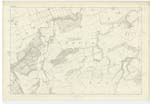
011 | [Situation] About a mile and a 1/4 N. by W. [North by West] from Garvald A small hill on the farm of Papple. On it is a Trigl. [Trigonometrical] Station called by Trigl. [Trigonometrical] Party "Lawhead". |
| CLARTYSIDE PLANTATION | Clartyside Plantation Clartyside Plantation Clartyside Plantation Clartieside |
Thomas Forbes Estate Map Thomas Smith List of Ploughgates |
011 | [Situation] About 1 1/2 miles N by E. [North by East] from Garvald. A belt of plantation consisting of Fir and Oak. Situated on the West side of Whittingham Water |
| WHITTINGHAM WATER | Whittingham Water Whittingham Water Whittingham Water Whittingham Water Whittingham Water |
George Peacok Robert Durie Estate Map Stat. Acct. [Statistical Account] Fullarton's Gazetteer |
011 | [Situation] Runs in a N.E. [North East] direction past the west Side of Whittingham A considerable Stream or burn having its rise in the parish of Garvald and running in a N. [North] easterly direction throw Whittingham thro' [through] Whittingham demesne to its influx with Beil Water near Grange farm house It is called Papana Water as far north as Papple Bridge from this bridge northward it is called Whittingham Water |
Continued entries/extra info
[Page] 3Parish of Whittingham
Form 136 Page
60 Lawhead Hill
68 Clartyside Plantation
64 Whittingham Water
[Note] It is Called 'Beil Water' from its junction with the Stream at Beilmill
Transcribers who have contributed to this page.
DANIALSAN, as@electroniccottage.co.uk
Location information for this page.
Linked mapsheets.