OS1/15/6/31


| List of names as written | Various modes of spelling | Authorities for spelling | Situation | Description remarks |
|---|---|---|---|---|
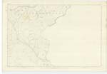
| PHILIP BURN | Philip Burn | Denholm Farmer Middle Monynut James Johnston Farmer Bushelhill |
017 | Its source is on the Peat Law. It flows from that in an Easterly direction and emptys itself into the Monynut Water. It forms the County Boundary. |
| SKINNER BURN | Skinner Burn | Denholm Farmer Middle Monynut James Johnston Farmer Bushelhill |
017 | Its source is on the Ewe Layers. It runs from that in a Southerly direction and emptys itself into the Monynut Water. |
| EWELAIRS HILL | Ewe Layers Hill | Mr. David Denholm Farmer Middle Monynut James Johnston Farmer Bushelhill |
017 | A middle sized hill a little to the North of Middle Monynut farm house. Its surface is heathy pasture and on its summit stands a Trig [Trigonometrical] Pole called "Ewelairs". Between it and Heart Law there is a sheltered glen where sheep brought forth their young. To that circumstance it owes its name. |
Continued entries/extra info
[Page] 31List of Names collected by P. McHugh Pte. RS&M [Private Royal Sappers & Miners]
Plan 17C Trace 3
Parish Innerwick and Oldhamstocks
Object
Philip Burn - Stream
Skinner Burn - Stream
Ewe Layers Hill - Hill
Transcriber's notes
Goes Bank scored throughTranscribers who have contributed to this page.
DANIALSAN, wilson5bh
Location information for this page.
Linked mapsheets.