OS1/10/55/7


| List of names as written | Various modes of spelling | Authorities for spelling | Situation | Description remarks |
|---|---|---|---|---|
| CAULDKINE RIG | CalKin Rig CalKin Rig CauldKine Rig |
Thomas Dalgleish CalKin Foot James Park Loganhead F. Elliot |
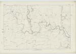
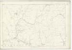
044 | [Situation] About ¾ of a mile N.W [North West] of Loganhead. A large hill on Hopsrig Farm of a Ridge like shape covered with Rough Pasture, bounded on the west by ClacKanna and on the east by CalKin SyKe the property of His Grace the DuKe of Buccleuch |
| CLACKANNA SIKE | ClacKanna Sike | Thomas Dalgleish James ParK |
044 | [Situation] Flows South from Ewe Hill. A small stream arising out of CalKin Rig and flowing in an Northerly direction untill joins BoyKin Burn. |
| CLACKFAIRN SIKE | ClacKfairn Sike | Thomas Dalgleish James ParK |
035; 044 | [Situation] Flows South from CauldKine Rig. A small stream which rises out of CalKin Rig and flows in a northerly direction untill it joins BoyKin Burn. |
Continued entries/extra info
[Page] 7WesterKirK Parish Sheet 44 No. 4 Trace 1
BoyKin Burn - See page 5
The Shin - See Name Sheet for Plan 35/16 Book No. 4
Transcribers who have contributed to this page.
DANIALSAN, Brenda Pollock
Location information for this page.