OS1/10/50/29


| List of names as written | Various modes of spelling | Authorities for spelling | Situation | Description remarks |
|---|---|---|---|---|
| BELLCRAIG BURN | Bellcraig Burn Bellcraig Burn Bellcraig Burn |
Robert Falkner (Folds) John Pagan (Breckonside) Thomas Barrie (Poldean) Charles Stewart Esq [Esquire] Hillside |
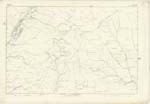
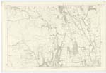
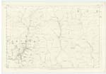
017; 024; 025 | A Rivulet having its source about two miles to the north of Poldean, and forms the boundary for a short distance betwixt the Parishes of Wamphray and Moffat, at length falling into the River Annan. Bell originally from Belevd, a Marten, |
| Site of FORT [The Dod] | British Fort(site) British Fort(site) British Fort(site) |
Robert Falkner (Folds) John Pagan (Breckonside) Thomas Barrie (Poldean) |
024 | This is the site of a British Fort situated on the farm of Poldean, its shape is that of a circle but it is much defaced by the process of cultivation that its original shape cannot be a accurately distinguished, that it is a British Fort appears to be the belief of all the intelligent persons acquainted with the locality. It appears to have had a rampart on the South side, The North side was fortified by Nature, being the side of a steep Brae, The Fort and the hill, called The Dod are of some extent in Magnitude. |
| THE DOD | The Dod The Dod The Dod |
Robert Falkner (Folds) John Pagan (Breckonside) Thomas Barrie (Plodean) |
024 | An eminence of considerable elevation, and commands a delightful prospect, and on which is situated the site of a British Fort. |
Continued entries/extra info
29 Parish of Wamphray Plan 24.4 Trace 2The Dod situation about 56 Chains North East from Poldean
Bellcraig Burn situation From the junction of runners at the North East end of Washy Bog. On the boundary of Wamphray and Moffat.
British Fort (site) situation on the Dod
Philip Munro Lance Corporal Royal Engineers
M Donohue
Transcribers who have contributed to this page.
stellas
Location information for this page.