OS1/10/50/178


| List of names as written | Various modes of spelling | Authorities for spelling | Situation | Description remarks |
|---|---|---|---|---|
| LANGSIDE | Langside Langsyde |
Estate Map dated 1765 Mr Rogerson Fingland John Little resident Ancient and Modern Valuation Roll of the County |
034 | A Shepherd's house with outhouses in bad repair, Situated near the Southern boundary of the parish, and a mile east from the Annan. formerly a small farm town. |
| LANGSIDE HILL | Langside Hill | Estate Map of 1765 Mr Rogerson Fingland John Little Langside |
034 | A pretty high hill of uncultivated ground, a little East from Langside. |
| SCALE HILL | Scale Hill | Mr Rogerson Fingland John Little Langside Alexander Rogerson Girthhead |
034 | A hill of uncultivated ground a little South East from Langside. formerly cultivated now a Parish pasture. |
Continued entries/extra info
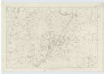
178 Parish of Wamphray Sheet 34.5 Trace 2Langside situation About 1 mile North West from Hazelbank
Scale Hill situation About 67 Chains North West from Hazelbank
Langside Hill situation About 66 Chains North West by North from Hazelbank.
John Jane Sapper Royal Engineers
Transcribers who have contributed to this page.
stellas
Location information for this page.
Linked mapsheets.