OS1/10/50/164


| List of names as written | Various modes of spelling | Authorities for spelling | Situation | Description remarks |
|---|---|---|---|---|
| BONE CLEUCH | Bone Cleugh | Kohn Rogerson James Rogerson John Carruthers Kirkhill |
034 | A narrow glen, planted with fir trees, situated a short [--] north from Fingland farm. |
| CUMSTONSTUCK | Cumstonstuck Cumieston stack |
Estate map James Rogerson John Rogerson An Ancient and Modern Valuation Roll of the County |
034 | A small plantin of large spruce trees, of about 30 years growth. situated about a mile South West from Fingland farm house The site of this was formerly a farm town. Cum or Cam, a bend or crookstandard in the Celtic speech. Cumstanestuck seems to be the correct stack from Celtic Stuc a knowe [---] |
| FINGLAND | Fingland | Estate Map John Rogerson farmer James Rogerson Fingland |
034 | A farm with commodious dwelling and office houses including a threshing machine propelled by water etc. Situated about one mile South East from the Parish Church. |
| FINGLAND LINN | Fingland Linn | John Rogerson James Rogerson | 034 | A narrow but deep glen, the sides of which are partly wooded, with trees of natural growth. |
Continued entries/extra info
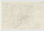
164 Parish of Wamphray Sheet 34.1 Trace 6unable to read extreme right of page.
Fingland situation 1 Mile South East from Saughtrees
Fingland Linn situation From Fingland extending East
Bone Cleugh situation 11 Chains North from Fingland
Cumstonstuck situation 25 Chains South West from Fingland
John Jane Sapper Royal Engineers
Transcribers who have contributed to this page.
stellas
Location information for this page.
Linked mapsheets.