OS1/10/48/50


| List of names as written | Various modes of spelling | Authorities for spelling | Situation | Description remarks |
|---|---|---|---|---|
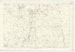
| WYLIEHOLE | Wyliehole Wyliehole Wyliehole |
Revd. [Reverend] Richard Sanders Scheme of locality for July 1794 Mr. John Richardson |
043 | [Situation] 1/2 mile SW. [South West] from Whitestone Hill. A farm town in good repair Mr. John Swan is owner and Occupier. |
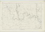
| WATER OF MILK | Milk Water Milk Water Milk Water Water of Milk |
Revd. [Reverend] Richard Sanders Blacks Co. [County] Map Mr. Johnstone of Gibson See following Page |
035; 043; 044; 051; 052 | [Situation] On the Wn. [Western] Parish Boundary. A small river which takes its rise in this Ph. [Parish] and after a course of about 14 or 15 miles E. [East] to W. [West] falls into the Annan a little above Hoddam Castle |
Continued entries/extra info
[Page] 50Parish of Tundergarth -- Plan 43.16 Trace 5
[Signed] M Donohue
Febr [February] 1857.
Transcribers who have contributed to this page.
CorrieBuidhe- Moderator, Brenda Pollock
Location information for this page.
Linked mapsheets.