OS1/10/48/19


| List of names as written | Various modes of spelling | Authorities for spelling | Situation | Description remarks |
|---|---|---|---|---|
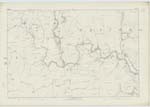
| WATER OF MILK | Milk Water Milk Water Milk Water Water of Milk |
Fullartons Imperial Gazetteer Johnstones County Map Blackwoods County Map See Page 17 |
035; 043; 044; 051; 052 | [Situation] On Wn. [Western] Parish Boundary. A large stream rising near Little Hartfell it forms the N.W. [North West] boundary of the Parish & falls into the River Annan near to Hoddam Castle. |
| CAPEL BURN | Capel Burn Capel Burn Capel Burn |
Thomas Armstrong Shepherd Walter Armstrong Shepherd Thomas Common Farmer |
044 | [Situation] From S.E. [South East] corner of Plan N.W. [North West] to Milk Water. A small burn rising on the W [West] side of Papert Hill, the name applies to it from the junction of Cheese & Coom Burn's to its confluence with Milk Water at Capelfoot. |
Continued entries/extra info
[Page] 19Parish of Tundergarth -- Plan 44.6 Trace 1
[Signed] Charles J Fearnside
Sapper R.E. [Royal Engineers]
Transcribers who have contributed to this page.
CorrieBuidhe- Moderator, Brenda Pollock
Location information for this page.
Linked mapsheets.