OS1/10/45/28


| List of names as written | Various modes of spelling | Authorities for spelling | Situation | Description remarks |
|---|---|---|---|---|
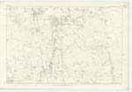
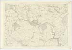
| GIMMENBIE BURN | Gammonbie Burn Gammonbie Burn Gammonbie Burn Gammonbie Burn Gimmanby Gimmenby |
J. Jardine (ShoemaKer) J. Murray (Farmer) J. Jamieson (Farmer) J. Johnstone (Farmer) Johnstons Co. [County] Map Valuation Rolls |
051 | [Situation] On En. [Eastern] Parish Boundary. A considerable Stream, having its Source in the Ph. [Parish] of Tundergarth And flows in a South Westerly direction into the Water of Milk about 10 Chains above Castlemilk Bridge. Gammonbie the dwelling in or by the projection or shoulder may be correct. |
| CLEUGHSIDE BURN | Cleughside Burn | J. Jardine (ShoemaKer) J. Murray (Farmer) J. Jamieson (Farmer) J. Johnstone (Farmer) |
051; 057 | [Situation] On En. [Eastern] Parish Boundary. A Small Stream rising on the farm of Cleughside and running in a northerly direction until it joins the Gammonbie Burn. For a considerable distance Cleughside Burn forms the Boundary between the Parishes of Hoddam and St. Mungo |
Continued entries/extra info
[Page] 28Parish of St. Mungo -- Sheet 51 No. 10 Trace 2
[Signed] Thomas Watson
2nd Corp. R.E. [Corporal Royal Engineers]
Transcribers who have contributed to this page.
Chr1smac -Moderator, DANIALSAN
Location information for this page.