OS1/10/44/29


| List of names as written | Various modes of spelling | Authorities for spelling | Situation | Description remarks |
|---|---|---|---|---|
| GLENBUIE BURN | Glenbuie Burn Glenbuie Burn Glenbuie Burn Glenbuie Burn |
Walter Anderson John Mitchell John Stewart Estate Map. 1831. |
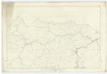
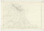
002; 003 | [Situation:] From a point about ¾ mile N. E. [North East] from Craignorth Hill - N. E. [North East] to Wanlock Water] A small Rivulet which rises near Coghead and falls into Wanlock Water |
| DUNTERCLEUCH RIG | Duntercleugh Rigg Duntercleugh Rigg Duntercleugh Rigg Duntercleugh Rig |
Walter Anderson John Mitchell John Stewart Rev. [Reverend] R. Simpson See page 36 for Glendorch Rigg |
003 | [Situation] 5 miles N.E. [North East] from Sanquhar Burgh, A Considerable hill on the lands of Duntercleugh Its Soil consists of Mountain Grass Land. |
| WANLOCK WATER | Wanlock Water Wanlock Water Wanlock Water |
Walter Anderson John Mitchell John Stewart |
002; 003; 007 | [Situation:] From the Lead Mines at Wanlockhead N W. [North West] to Crawick Water. A small River having its source at Wanlockhead and falls into Crawick Water. |
Continued entries/extra info
[Page] 29.Parish of Sanquhar -- Plan 3.13 Trace 1
[DUNTERCLEUCH RIG - List of Names:]
"Rig" adopted on
the Plans at the
Examination Office
[Page is signed]
Philip Munro
Pte [Private] RS&M [Royal Sappers and Miners]
Transcribers who have contributed to this page.
Chr1smac -Moderator, George Howat
Location information for this page.