OS1/10/44/267


| List of names as written | Various modes of spelling | Authorities for spelling | Situation | Description remarks |
|---|---|---|---|---|
| QUINTIN'S BURN | Quintin,s Burn Quintin,s Burn Quintin,s Burn |
Mr. William Critchon Mr. William Armstrong Mr. John Sharpe |
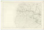
012 | A small rill which has its rise in Brunt Slack runs in a Northward direction and falls into Kello Water, |
| THWARTER BURN | Thorter Burn Thorter Burn Thorter Burn Thwarter Burn Thwarter Burn |
Mr. William Critchon Mr. William Armstrong Mr. John Sharpe Johnston's County Map Crawford's County Map |
005; 006; 012; 013 | A rill which has its rise on the West of Drumbuie Muirhead, runs in a Northward direction, and forms a Confluence with Kello Water. |
| DRUMBUIE MOORHEAD | Drumbuie Muirhead Drumbuie Muirhead Drumbuie Muirhead |
Mr. William Armstrong Mr. William Armstrong Mr. John Sharpe |
012 | A district of Mountain grass-land on the farm of Drumbuie, It is an Old Name and well known, |
Continued entries/extra info
[Page:] 267,Parish of Sanquhar -- Plan 12.4 Trace 3
[QUINTIN'S BURN - Situation:]
From Brunt Slack
S,W,W, [South West West] to March
Burn-
[THWARTER BURN - the List of Names column has a comment regarding the Name:]
Adopted on the Plan
[THWARTER BURN - Situation:]
From the S. En. [South Eastern]
base of Brunt
Rigg - N,N,E, [North North East]
to Kello Water,
[DRUMBUIE MOORHEAD - Situation:]
½ mile S,E, [South East] from
Brunt Rigg,
[Page is signed:]
M Donohue 17th. Oct [October] 1856
Transcriber's notes
QUINTIN'S BURN- one of the authors of the page uses 'comma' instead of 'apostrophe', I have transcribed as written.
Transcribers who have contributed to this page.
George Howat
Location information for this page.