OS1/10/44/167


| List of names as written | Various modes of spelling | Authorities for spelling | Situation | Description remarks |
|---|---|---|---|---|
| LITTLE ARTHUR GRAIN | Little Arthur Grain Little Arthur Grain |
James Mitchell Old Estate Map Mr James Stewart |
007 | A small Burn rising at the Head of Stake Mofs [Moss] [strike out initialled:] C J.F. and running in a Westerly direction. It falls into Mossy Burn |
| MEIKLE ARTHUR GRAIN | Meikle Arthur Grain | James Mitchell Old Estate Map Mr James Stewart |
007 | A Small Burn rising at the Louther Hills and runs in a West & South West direction & falls in to Whitsoncleugh Burn. |
| STAKE MOSS | Stake Mofs [Moss] | James Mitchell Old Estate Map Mr James Stewart |
007 | A district of Moor [strike out initialled:] C. J. F. East of Wanlock Head, very rough & Heathy but the Mofs [Moss] in some places does not exceed 1 foot in depth. |
Continued entries/extra info
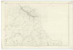
[Page:] 167,Parish of Sanquhar -- Plan 7.11 Trace 1
[LITTLE ARTHUR GRAIN - Situation:]
At the head of
Stake Mofs, [Moss] NW, [North West]
to Mofsy [Mossy] Burn
[STAKE MOSS - Situation:]
Adjoining Wanlock -
= head on the S,E, [South East]
extending East to
Eastern Parish Boundary
[MEIKLE ARTHUR GRAIN - Situation:]
From ¼ mile
South of Stake
Mofs [Moss] near En. [Eastern] Parish
Boundary - S.W. [South West] to
Whitestone Cleuch.
[Page is signed:]
Charles J Fearnside
Pte. [Private] R.S.&M's. [Royal Sappers and Miners]
Transcribers who have contributed to this page.
George Howat
Location information for this page.
Linked mapsheets.