OS1/10/43/88


| List of names as written | Various modes of spelling | Authorities for spelling | Situation | Description remarks |
|---|---|---|---|---|
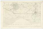
| SOLWAY FIRTH | Solway Firth Solway Firth Solway Firth |
Chambers Atlas James Scott James Kelton |
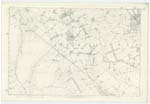
061; 066 | [Situation] Washing Ruthwell Parish at the South An arm of the North Channel running in a, N,E [North East] direction from Balmea Head in the South of KirKubright - to DordocK in the S.E. of Dumfriesshire, It also devides KirKubright and Dumfriesshire from Cumberland It is navigable at high water as far as DordocK. |
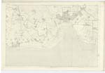
| PRIESTSIDE BANK | Priestside Bank or Solway Sands Priestside Bank or Solway Sands Priestside Bank or Solway Sands |
James Scott James Kelton Samuel Armstrong |
061; 062 | [Situation] At the Sn [Southern] extremity of Ruthwell Parish A large tract of sands extending nearly across the Solway Firth Formerly the inhabitants of this Parish made salt from the Sands and found it a very profitable buisness until duty was taken off salt. See Page 2, |
| LOCHAR WATER | Lochar Water Lochar Water Lochar Water |
James Scott James Kelton Samuel Armstrong |
056; 061 | [Situation] Forming Wn. [Western] Parish Boundary and running in a S. En [South Eastern] direction along Priestside Bank, A large stream bearing this name from Locharbriggs in the Ph [Parish] of Tinwald, It flows in a Southerly direction through Lochar Moss In its course forms the Boundary between several Parishes and empties its self into the Solway Firth 2 Miles west of Ruthwell village |
Continued entries/extra info
[page] 88Parish of Ruthwell -- Plan 61.8 -- Trace 4
[Note Priestside Bank] -- ? [at end of line after Sands]
[signed] Samuel S. Hill Lce.Corpl RS&M [Lance Corporal Royal Sappers & Miners]
Transcribers who have contributed to this page.
Moira L- Moderator, norma
Location information for this page.