OS1/10/43/107


| List of names as written | Various modes of spelling | Authorities for spelling | Situation | Description remarks |
|---|---|---|---|---|
| EAST UPPERTOWN | East Uppertown East Uppertown East Uppertown |
Samuel Grierson George Grierson David Fergusson |
061 | [Situation] 1 mile S,S,E. [South South East] from Ruthwell village A good Farm house with offices garden & Farm of land attached the property of Lord Mansfield |
| ROXBURGH'S ROAD | Roxburgh's Road Roxburgh's Road Roxburgh's Road |
Samuel Grierson Mrs Underwood David Fergusson |
061 | [Situation] About 1/4 mile N,E, [North East] of Ruthwell village extending South A Ph. [Parish] road extending from West Uppertown Cottage in a northerly direction untill it meets the Public Road at Greenfield, so called from the man who made it |
| HOW CREEK | How Creek How Creek Creek The Creek |
Samuel Grierson David Fergusson William Robson |
061 | [Situation] From Priestside Flow running S. [South] and forming a part of Eastern Parish Boundary. a small stream receiving the drainage of Priestside Flow and separating the Phs [Parishes] of Ruthwell and Cummertrees It flows in a direction southwards and then west untill it falls into Lochar water. The name is derived from the low tract of moss through which it flows |
Continued entries/extra info
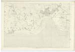
[page] 107Parish of Ruthwell -- Plan 61.12 -- Trace 3
[signed] John Houston
Transcribers who have contributed to this page.
Moira L- Moderator, norma
Location information for this page.
Linked mapsheets.