OS1/10/43/1


| List of names as written | Various modes of spelling | Authorities for spelling | Situation | Description remarks |
|---|---|---|---|---|
| RUTHWELL [parish] | Ruthwell Ruthwell Ruthwell |
Walker's Map or Scotland Johnston's Map of Dumfriesshire Crawford's Map of Dumfriesshire |
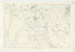
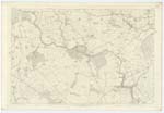
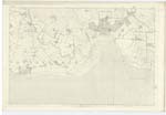
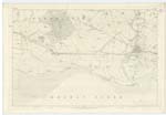
056; 057; 061; 062; 066 | [Situation] At the Sn [Southern] extremity of the Co. [County] of Dumfries The Name of this Parish is said to be derived from the Anglo-Saxon Rith a Rivulet and Weald a woody place. The village of Ruthwell stands on a rivulet which falls into the Solway Firth about a mile below, part of the Ancient Woods may be said to exist in that of Comlongon Wood about a mile N. W. [North West] from the village. The Etymology of the second Syllable may be farther confirmed by the nearly similar terminations of the adjoining Parishes of Mouswald, Torthorwald And Tinwald all of which include within their limits portions of Lochar Moss as well as Ruthwell, - the various remains of imbedded trees which have been dug up shewing this Morass to have been at an early date a continuous forest. The Parish of Ruthwell is bounded on the North by those of Mousewald and Dalton, - on the East by Cummertrees and on the West by Carlaverock. - The Boundaries are thus detailed, - on the North Centre of the Black Grain, Centre of Bank, undefined, centre of Bank, Root of Hedge, undefined, Track of Old Fence, Centre of Stream, Centre of Wall, Root of Hedge, Centre of Bank, Root of Hedge, Centre of Wall, undefined, Root of Hedge, undefined, Centre of Stream, Centre of Wall, undefined & Centre of Wall, - On the East, Centre of Wall, Centre of Bank, Root of Hedge, undefined Root of Hedge undefined, Root of Hedge undefined, face of wall, centre of Stream, undefined, centre of Stream, centre of ditch, undefined, Centre of Bank, Root of Hedge, undefined, Centre of Ditch, undefined, Centre of Ditch, Centre of Stream, track of Stream, on the South Solway Firth And on the West Centre of Lochar Water and centre of Cop. - There is no detached part of Ruthwell within the Boundaries of another Parish neither is there within its limits as above described a detached portion of another Parish. - Its shape is irregular, its length from W. [West] to East may be 5 1/2 miles and mean breadth 2 1/2 miles and in its Area as [?] Statistics has been computed at nearly 14 Square miles or 8,420 Impl. [Imperial] Acres of which 5,600 are Arable, 520 wood, 1300 Moss, 1,000 Merse or land subject to be overflowed by the tide. The entire Surface may be termed flat, the elevations that occur not rising in any instance above 90 feet. The Soil is various, but consists generally of a strong gravel intermixed with vegetable Mould, towards the [Continued on page 1A] |
Continued entries/extra info
[Page] 1Parish of Ruthwell
Co [County] Dumfries
Transcribers who have contributed to this page.
Moira L- Moderator, Nora Edwards, EDAVID90
Location information for this page.
Linked mapsheets.