OS1/10/39/168


| List of names as written | Various modes of spelling | Authorities for spelling | Situation | Description remarks |
|---|---|---|---|---|
| LITTLE BLACK GRAIN | Little Black Grain Little Black Grain Little Black Grain |
Andrew Little John Renwick William Johnstone James Renwick Selcoth |
017 | A small mountain stream which rises at the North base of Loch Fell, and falls into Selcoth Burn. |
| PARK'S WELL | Parks Well Parks Well Parks Well |
Andrew Little John Renwick William Johnstone |
017 | A spring well so named being dug by a man named Park about 40 years ago. |
| SELCOTH BURN | Selcoth Burn Selcoth Burn Selcoth Burn Salecoth Selcoth |
Andrew Little Sailfoot John Renwick Selcoth William Johnstone Craigieburnwood Johnston's County Map Valuation Rolls 1827 |
017 | A considerable stream having its source at a point about 1/2 mile West from Windfell, and winds in a North Westerly direction until it joins Moffat Water. |
Continued entries/extra info
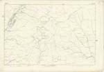
Page 168 Parish of Moffat Sheet 17.7 Trace 1Selcoth Burn situation From the junction of Black and Little Black Grains North West to Moffat Water.
Parks Well situation 27 Chains North West from Windfell Nick.
Little Black Grain situation West of Black Grain
john Jane Sapper RE[Royal Engineers]
Transcribers who have contributed to this page.
stellas
Location information for this page.
Linked mapsheets.