OS1/10/38/175


| List of names as written | Various modes of spelling | Authorities for spelling | Situation | Description remarks |
|---|---|---|---|---|
| ROUNDSTONEFOOT BURN | Roundstonefoot Burn | James Johnstone, Copplegill David Johnstone, Copplegill David Bryden, Bodsbeck |
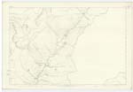
010 | [Situation] From 1/2 mile South of Nether Comb Craig S.S.E. [South South East] to Moffat Water. Takes its rise at a point about a mile North of Roundstonefoot farm steading, and forms the march betwixt that farm, and Copplegill, for some distance. |
| LITTLE SIKE | Little Syke Little Syke Little Syke Sike - a hill |
James Johnstone, Copplegill David Johnstone, Copplegill David Bryden, Bodsbeck Dr. Jamieson's Sc. [Scots] Dictionary |
010 | [Situation] East of Roundstonefoot Burn. A rivulet which rises about a mile to the N.W. [North West] of Copplegill, and flows in a southerly direction until it joins Roundstonefoot Burn. |
Continued entries/extra info
[Page] 175Parish of Moffat Sheet 10.9 Trace 5
[signed] John Jane Sapper R.E. [Royal Engineers]
Transcribers who have contributed to this page.
norma
Location information for this page.
Linked mapsheets.