OS1/10/38/135


| List of names as written | Various modes of spelling | Authorities for spelling | Situation | Description remarks |
|---|---|---|---|---|
| MOFFAT WATER | Moffat Water Moffat Water Moffat Water |
Mr Robert Johnstone farmer Polmoody John Broadfoot Shepherd Birkhill William Brown Shepherd Birkhill |
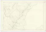
004; 010 | A stream which rises at Birkhill, and runs Southward until it joins the River Annan |
| MIRK SIDE | Mirk Side Mirk Side Mirk Side Mirk Side Mirk Side |
Mr Robert Johnstone farmer Birkhill John Broadfoot William Brown Johnstons County Map Crawfords County Map |
004; 010 | This name is applied to the mountain range, which extends along the Southern boundary of the parish, from Birkhill about 4 1/2 miles Southward and terminates at Bodesbeck Law. |
Continued entries/extra info
Page 135 Parish of Moffat Sheet 10.7 Trace 1Moffat Water situation From North East district South West to River Annan
Mirk Side situation In the North Eastern district
John Jane Sapper Royal Engineers
Transcribers who have contributed to this page.
stellas
Location information for this page.