OS1/10/34/51


| List of names as written | Various modes of spelling | Authorities for spelling | Situation | Description remarks |
|---|---|---|---|---|
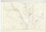
| ROUGH BURN | Rough Burn Rough Burn Rough Burn |
Adam Todd Rosetta John Dinwoodie Lawesknowe John Johnstone Hillhead |
016 | A small stream that takes its rise on the farm of Longbedholm and flows in a Southward direction and falls into Garpol Water |
| GARPOL WATER | Garpol Water Garpol Water Garpol Water |
Adam Todd John Dinwoodie John Johnstone |
016 | A stream that takes its rise in the County of Lanark and flows in a South Easterly direction and falls into Evan Water |
Continued entries/extra info
[page] 51Parish of Kirkpatrick Juxta
Plan 16/10 Trace 1
[Text in Situation column]
[Rough Burn] From the S.W. [South West] side of Longbedholm Hill S. [South] to Garpol Water
[Garpol Water] From the NWn Ph [North Western Parish] Boundary S.E.E. [South East by East] to Evan Water
[signed] James Cowan c/a [civilian assistant]
Transcribers who have contributed to this page.
norma
Location information for this page.
Linked mapsheets.