OS1/10/34/136


| List of names as written | Various modes of spelling | Authorities for spelling | Situation | Description remarks |
|---|---|---|---|---|
| KINNEL WATER | Kinnel Water Kinnel Water Kinnel Water |
Thomas Proudfoot Craigielandshill John Martin Stanchilridge John Brown Callum |
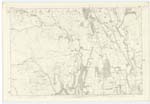
A small that rise near the North side of this County and flows in a South Easterly direction and falls into the River Annan | |
| FORT [SE of Wardlaw] | British Fort (site of) British Fort (site of) British Fort (site of) British Fort (site of) |
C. Stewart Esqr (Hillside) J. Hastie Marchbank Toll Thomas Proudfoot John Martin John Brown |
024 | A small piece of rising ground that has every appearance of having been used as a place of strength, there is a great quantity of stone and earth thrown up into an oval form; there has been a division near to the North East end. |
| BYRE BURN | Byre Burn Byre Burn Byre Burn |
Thomas Proudfoot John Martin John Brown |
024 | A stream that rises on the farm of Stiddrig and flows in a North Easterly direction and falls into Kinnel Water |
Continued entries/extra info
[page] 136[Parish] of Kirkpatrick Juxta
Plan 24/2 Trace 4
[Text in Situation column]
[Kinnel Water] From N.Wn Ph [North Western Parish] Boundary S.E. [South East] onto Sn Ph [Southern Parish] Boundary
[Fort] About 1/2 mile S.E. [South East] of Wardlaw
[Byre Burn-Entry in Situation column crossed out and "alter this" pencilled over it]
James Cowan c/a [civilian assistant]
Transcriber's notes
Kinnel Water added by me.Transcribers who have contributed to this page.
norma
Location information for this page.
Linked mapsheets.