OS1/10/33/1


| List of names as written | Various modes of spelling | Authorities for spelling | Situation | Description remarks |
|---|---|---|---|---|
| KIRKPATRICK FLEMING | Kirkpatrick-Fleming | Walkers' Map of Dumfriesshire Crawford's Map of Dumfriesshire Johnston's Map of Dumfriesshire |
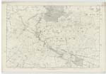
052; 058; 059; 063; 064 | [situation] In the SEn [South Eastern] district of Dumfriesshire The Parish of Kirkpatrick-Fleming is bounded on the North by that of Middlebie, on the East by Half-Morton and Gretna on the South by Gretna and on the west by Dornock, Annan and Middlebie. There is no part of it detached nor is there a detached portion of another Parish within the limits above assigned to it. It resembles a rhomboid in shape, measures about 6 miles from North to South and varies from 13/4 to 3 miles in breadthfrom west to East. Its entire area has been computed at 11,572 Acres of which about 2/3 is arable. The surface rises slowly in a pleasing variety of successive waving swells from South to North. The principal Streams are Kirtle Water on the Wn. [Western] boundary and running S.E. [South East] through the Sn [Southern district and Black Sark which rises in the interior. The entire district is well watered by numerous springs and rills, some of former being of mineral repute. The Caledonian Railway from Glasgow and Carlisle runs in a S.E. [South East] direction across the Parish. The Glasgow and Carlisle Turnpike [continued on page 2] |
Continued entries/extra info
[page] 1Parish of Kirkpatrick Fleming County of Dumfries
The Name of this Parish is said to be derived from the Irish tutelary Saint St Patrick - Fleming the name of a proprietor of the district in the 14th Century having been added to distinguish it from other Parishes of the same name.
Transcriber's notes
The Description is continued on the next page (page 2)Transcribers who have contributed to this page.
CRIMSON
Location information for this page.
Linked mapsheets.