OS1/10/32/1


| List of names as written | Various modes of spelling | Authorities for spelling | Situation | Description remarks |
|---|---|---|---|---|
| KIRKMICHAEL | 023; 024; 032; 033; 041; 042 |
Continued entries/extra info
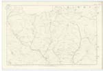
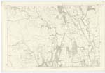
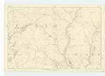
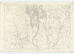
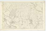
Parish of Kirkmichael No. 21 County of DumfriesJ.V.T. Walker´s Map of Scotland Near the middle of the The name is evidently derived from
Kirkmichael Crawford´s map of Dumfriesshire County of Dumfries. St. Michael, to which Saint the original
Johnstone´s map of Dumfriesshire Parish Church is said to have been dedicated.
The Parish of Kirkmichael is bounded on the North by that of Kirkpatrick-Juxta, on the East by Johnstone and Lochmaben, on the South by Tinwald and on the West by Kirkmahoe and Closenburn. There is no detached heart of it within the boundries of another Parish nor is there within it´s limits - here asigned by the above mentioned Parishes, a detached portion of any other Parish. It´s elliptical in form, is 9 miles in length and 4 1/2 miles in extreme breadth, and it´s entire area has now been computed at 17,131 acres, of which 6,761 acres may be arable and meadows, 9190 - pasture, 830 Mofs, Sandbeds, Roads,Lakes and Water courses and 350 Wood.
The surface in the south and south-east is in general level, but diversified with rising grounds, along the principal streamsthere are belts of fine holm, the soil in the low grounds is exceedingly fertile, in the middle districts it is dry and gravelly with heath occasionaly interspersed. The principal streams are the water of Ae on the western and southern boundaries, Kinnel and Duff Kinnel Waters on the eastern boundary, many tributary hills thereto taking their rise in the interior, the largest of which are Garrel Water and Glenkill Burn. There are also three small lochs, called Cran Loch, Cumrue Loch and Auchenaken Loch. There are two ranges of hills stretching nearly north and south, the one between the Water of Ae and Glenkill.
Transcribers who have contributed to this page.
eileenmcnaught
Location information for this page.
Linked mapsheets.