OS1/10/18/14


| List of names as written | Various modes of spelling | Authorities for spelling | Situation | Description remarks |
|---|---|---|---|---|
| MINE HILL | Mine Hill Mine Hill |
Thomas Smith Thickside Thomas Hast [Hastie] Caddom Hill |
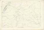
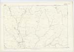
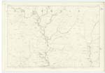
017; 018 | [Situation] About 1/2 mile S.E. [South East] of Blaeberry Shank A Considerable hill on the farm of Nether Cassock, And Situated to the north of Thickside Hass. It is Covered with rough pasture, And has a Trigonometrical Station on its Summit, called Mine Hill. |
| GARWALD WATER | Garwald Water Garwald Water Garwald Water Garvald Water Garvald Water |
James Connel Esqr. Irvine House Mr Thomas Hastie Shepherd, Kiddamhill Johnstons [County] Map Fullarton's Gazetteer Stat: acct: [Statistical Account] |
017; 026 | [Situation] N.W. [North West] portion of Eskdalemuir Parish A Small River formed by the junction of East & West Burns near Pengrain. It flows in a S.E [South East] direction to it's junction with the White Esk at Garwald - Waterfoot about 1/2 mile N.W. [North West] of Johnston. |
Continued entries/extra info
[Page] 14Parish of Eskdalemuir
Sheet 17 No. 12 Trace 6
Transcribers who have contributed to this page.
CorrieBuidhe- Moderator, gengirl44
Location information for this page.