OS1/10/13/91


| List of names as written | Various modes of spelling | Authorities for spelling | Situation | Description remarks |
|---|---|---|---|---|
| GLENESSLAND BURN | Glenesslin Burn Glenesslin Burn Glenesslin Burn Glenessland Burn Glenessland Burn Glenessland Burn Glenessland Burn |
F, J Wilson Esqr. Rev. Dr. [Reverend Doctor] Bryden Mr Joseph Barton Adam Clarke Esq Samuel Corson John Edgar Robert Austin |
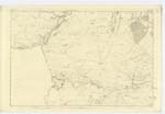
039; 040 | [Situation] From the N.W. [North West] Corner of this Plan, running in a S.Sn. [South Eastern] direction. A Stream rising in the upper part of Gelnessland and falling into Cairn Water It bears this name from the Confluence of Shillingland & Castramon Burns, to the Cairn Water, there can be no doubt but the name of the Vale & the Water should be written the same way. |
| GLENESSLAND [natural] | Glenessland Glenessland Glenessland Glenessland Glenessland Glenessland Glenesslin Glenesslin |
F. J. Wilson Esqr. Rev. Dr. [Reverend Doctor] Bryden Adam Clark Esqr. Samuel Corson Robert Austin John Edgar J Henning Fullartons Gazetteer |
039; 040 | [Situation] North & South of Glenessland Burn. A Valley Commencing at Glenesslin Distillery and running up to the base of Castramon Hill, The Glen to which this names is applied, extends on an average from half to threequarters of a mile to the north & South of the Glenessland Burn, but according to some the name includes the whole of the upper part of the Parish. According to Statistics 4 miles in length. - |
| NETHERTOWN | Nethertown Nethertown Nethertown Nethertown |
Mr William Gerrand Mr Joseph Barton Mr Robert Barber Val: [Valuation] Roll in 1827. |
040 | [Situation] Near the N.W. [North West] corner of this Plan. A dwelling house with garden, barns & other farm offices, and an extensive farm of land attached. |
Continued entries/extra info
[Page] 91Plan 70/13 Trace 1 Parish of Dunscore
Transcribers who have contributed to this page.
DANIALSAN, Stoofer
Location information for this page.