OS1/10/12/31


| List of names as written | Various modes of spelling | Authorities for spelling | Situation | Description remarks |
|---|---|---|---|---|
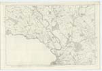
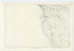
| RIVER NITH | River Nith Nith River River Nith |
Plan 27 B. Ainslies map. 1820 R. Kemp Esqr. Dumfries |
049; 055 | [Situation] Running Southerly past Dumfries &. Kingholm Quay village. A considerable river which rises at the S.W. [South West] end of the parish of New Cumnock in Ayrshire and runs thro' [through] the western portion of Dumfriesshire After receiving the river Cluden at Lincluden College, It then becomes the boundary between the counties of Kirkcudbright and Dumfries, and is considerably enlarged by the above river, then passing the town of Dumfries, at length falling into the Solway Firth. The tide swells the river as far up as the town of Dumfries and is navigable for vessels of from 60 to 100 tons burden The chief imports are Lime Guano &. Coals. Exports are all kinds of farming produce to Liverpool &c. |
Continued entries/extra info
[Page] 31Transcribers who have contributed to this page.
Chr1smac -Moderator, VickiColeman
Location information for this page.